Choreography of Logistics - The Architecture of the Consumer Society
Awarded the 2019 Vola Legat with Meggan Collins
This project is a critique on large ‘black box’ infrastructure which has occupied the peripheral landscapes of our cities for centuries, and more recently our urban fabric. Within this, the project explores the spatial challenges created by the on-demand society and proposes an alternative organizational model for the ‘networked’ city, through re-imagining distribution as a vehicle for new narratives of urban space.
1.0 - The Rise of the On-Demand Society
In the post-industrial and post-Fordist reality of today, the promise of same-day delivery is leading companies to move distribution centres closer and closer to large urban areas. Resulting in the return of industry, bringing with it countless million-square-foot ‘black boxes’ soon to be appearing in dense urban areas adjacent to highway infrastructure.
With urbanites representing 55% of the global population and with Copenhagen’s anticipation of further urbanization there are growing concerns over rates of resource consumption and distribution. Here it is imperative to address the environmental, economic and social sustainability of our cities.

With the rise of e-commerce, there has been a shift to an on-demand society which alongside urbanization is seeing increasing flows of people and goods. As a result, consumer satisfaction and delivery times have grown significantly important. Large e-commerce players, as well as various start-ups, have identified last-mile services as a key to meeting demands. Here there is growing recognition of the need to re-examine the interface between distribution methods and cities.
1.1 - The Road to a Carbon Neutral Copenhagen
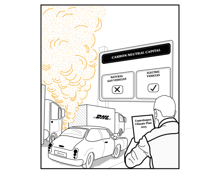
Following three decades of uninterrupted expansion, Copenhagen’s sustainable urban transport model is again seeking to reinvent itself. At a regional level, traffic congestion remains a major source of concern, with road traffic alone contributing 70% of transport emissions. In response, the City Council unanimously adopted the Climate Plan for Copenhagen with the ultimate vision of becoming the world’s first carbon-neutral capital by 2025.
However, with the increasing population and urbanisation rates, what is often not considered is that rising urbanisation, in turn, increases the flow of materials and goods, putting pressure on inner-city transport services.
Major challenges and opportunities lie in creating new initiatives and overlaps that allow for more flexible mobility, less congestion and pollution within the urban core. This is critical, given the spatial overlap used by the ‘last mile’ in freight, and that public transport demand is increasing; could more sharing of these resources be considered? This not only has the potential to alleviate the last mile problem for both types of transport, it could also be beneficial to the city, especially if Copenhagen is to reach its goal of Carbon Neutrality.
1.2 - The Last-mile problem
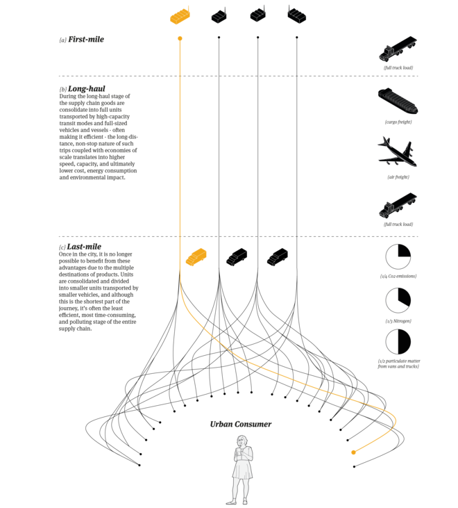
Distribution of goods from warehouses located far from the city’s outskirts has been increasingly challenging for delivery companies to efficiently deliver to urban-customers. The last leg of the supply chain represents the less efficient and most polluting. This is largely due to economies of scale, with goods switching from high-capacity to consolidated units divided by smaller vehicles. Therefore, the project aims at starting a discussion about how cities could open the window of opportunity to address the last mile challenges in a sustainable manner.

1.3 - Project Scope
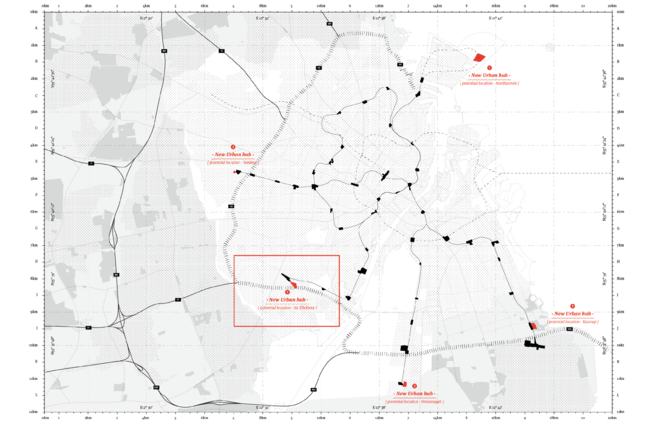
The project operates in two complementary scales: the scale of the city and the architectural scale of the citizen. The network scale explores at the level of Copenhagen’s municipality and existing metro network, whilst the architectural scale explores the tension between architecture, infrastructure, and landscape, allowing for more integrated territories and stimulating new forms of interaction; it’s within these moments of overlap where the architectural project unfolds.
2.1 – Re-imagining Copenhagen’s distribution network
Currently, Copenhagen's distribution system relies heavily on a truck-based distribution and existing road infrastructure, which is highly inefficient and polluting. We looked at possible ways of distributing goods without the need for large vans or trucks, due to Copenhagen having a vast public transport network we saw this as an opportunity.
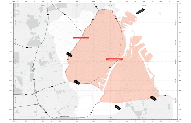
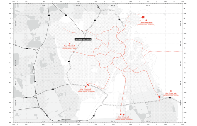
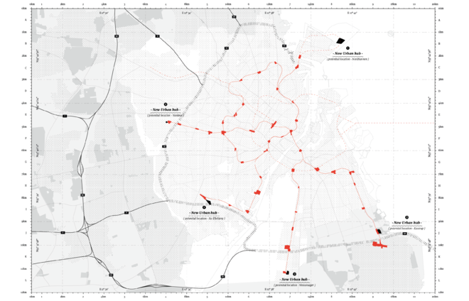
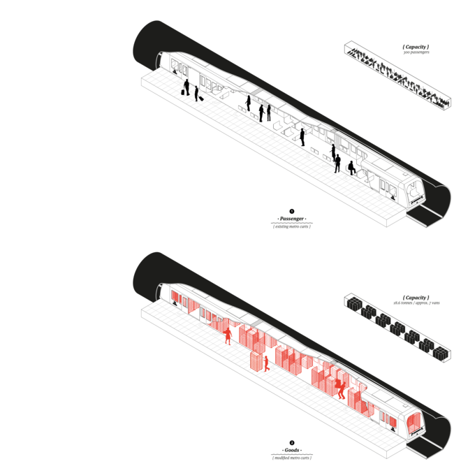
The strategy proposes a new low emissions zone for the city of Copenhagen that runs along the main 02 ring-road, where large vehicles are reduced to a minimum. Alongside the low emissions boundary new urban distribution centres are located, these act as switch points and mark where the new distribution network begins. The potential hubs are located at the terminus of the existing metro lines, allowing a switch from a truck-based distribution into a carbon-neutral last-mile network. Goods are transported within the metro cart itself and are delivered to metro stations within the city.
With this strategy we challenged the existing last-mile chain to allow the city to offer a more carbon-efficient way of meeting demands by utilising the existing infrastructure of the metro network, the new strategy can integrate itself into the existing fabric without much distribution.

2.2 – The Sharing of Infrastructure
The main challenge with this strategy is allowing it to coexist with the passenger network and existing infrastructure in the city of Copenhagen. In order to provide seamless integration, we focused on three key transport dimensions.

{a} Time
On the operational level of integration, the first and main objective is to maintain the seamless travel experience for metro passengers; this means a separation of ‘time-share’ between freight and people flows. Therefore, we analysed the existing peak and off-peak hours of the metro and established two windows of opportunity during off-peak hours where this could be possible.
{b} Vehicle
Combining urban passenger and goods flows on the same mode of transport has a lot of potentials, but due to the high-demands of the metro service during peak hours it isn’t feasible to reduce the capacity of passengers to two carts allowing the third to transport goods simultaneously. Therefore, the option of introducing a new parcel train seemed more feasible whilst also allowing the infrastructure of the metro carts to become an extension of the distribution centre.

{c} Space
With space being scarce in any city, the metro represents an acupunctural node that already exists in the city’s fabric. Currently, there is unused potential in inner-city metro stations in Copenhagen, with 200m2 of vacant space. Could this unused space facilitate a new pick up zone for goods within the existing parameters of the metro?
3.0 – Logistics Landscape
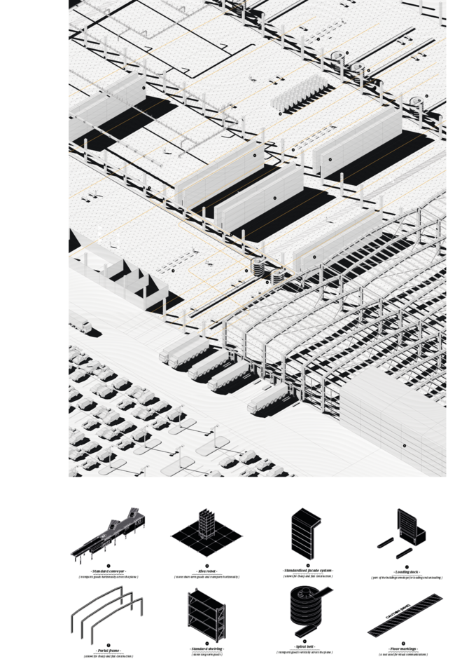
In order to approach this site, we had an analytical look at existing logistical infrastructure, to understand how it functions in a rural setting, three key characteristics emerged, the use of the ‘ground plane’, its repetitive structural system and lastly the façade.
3.1 – Site Analysis
{a} Ny Ellebjerg: Metro extension
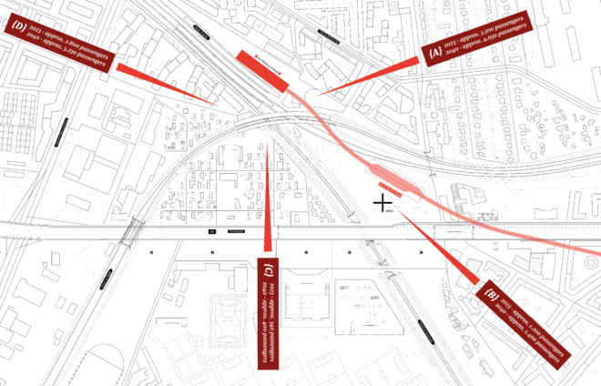
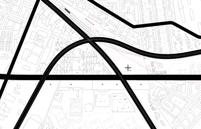
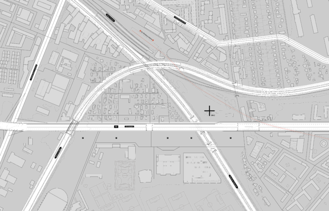
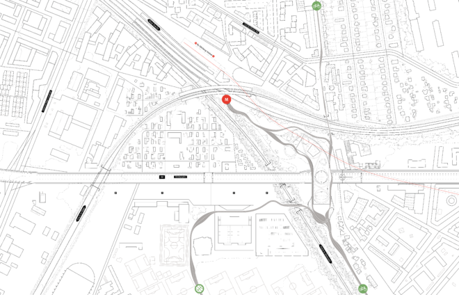
The site is situated in connection with Ny Ellebjerg Station, the southern terminus of the new Sydhavn Metro line {M4}. Scheduled to be completed in 2023, the station is to become a new critical traffic node for the city of Copenhagen. The station is expected to receive high volumes of foot-fall which would require a stronger connection to the surrounding residential areas
{b} Existing barriers: Railways and major roads
Although the area is planned to be of mixed-function (residential and industrial) this has contributed to a segregated and disjointed neighbourhood. Separated by clear functions, the mobility infrastructure only amplifies these existing barriers. This suggests the importance of introducing ‘transitions’ into the area to break down the barriers.
{c} Context: Programmatic
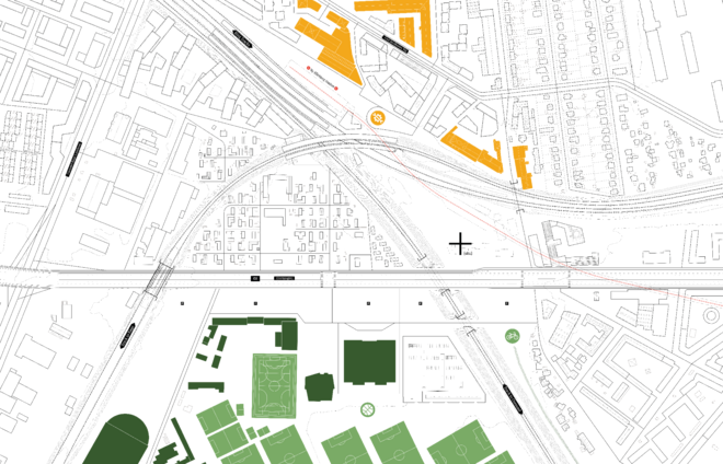
There are some key programmatic characteristics of this neighbourhood with the most prominent being the large sports facilities of Valby Idrætspark, which today is one of the major sports facilities within Copenhagen’s municipality. In connection, east of the sport facility is a new planned green bike connection, this green route is due to facilitate the flow of cyclists into the inner city, and to the North of the site which is dominated by creative businesses, technical schools and also workshops which inhabit the old industrial quarter of the neighbourhood. Here the site lies between two clearly defined programs, but today has no relation to either.
{d} Surrounding typologies
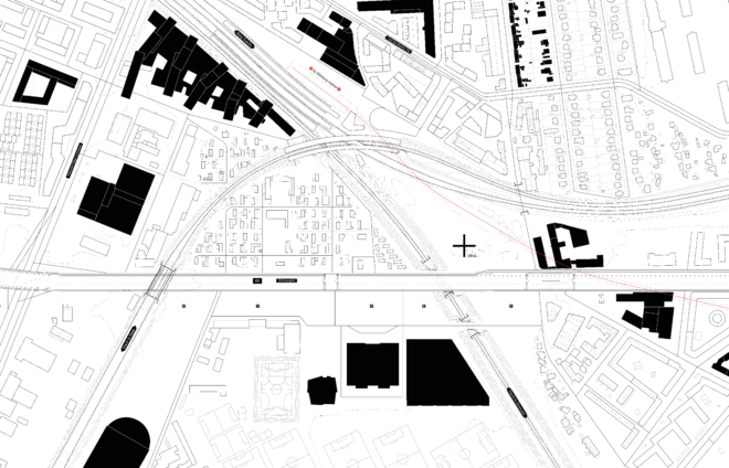
Even though the main focus lies in residential development, the area also supports offices and large-scale commodity shops which take up over 20.000 square meters of floor space. In fact, the area between the sports facilities and the Boulevard are considered to be one of the few places in CPH that is suitable for the placement of infrastructure with demanding commodity. Resulting in the area has no clear architectural typology, with the area ranging from row and terrace housing, bungalows, warehouses and large residential developments.

3.2 – Re-imagining the rural distribution centre: Architectural Concepts and Proposal
{a} Program
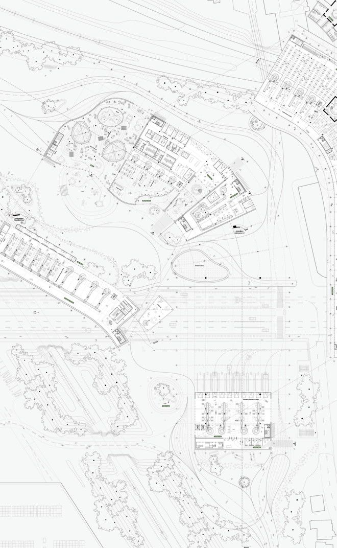
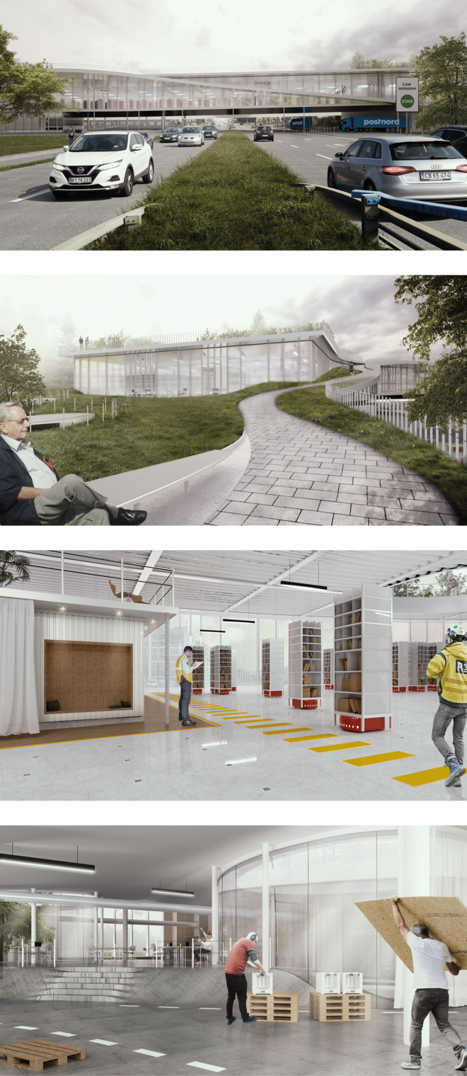
Traditionally in a rural setting, the program of a warehouse is mono-functional with the focus on purely providing a means of serving the on-demand society, therefore we propose that the urban typology integrates public amenities alongside its logistical programming in order to respond and engage with its surrounding context. This translated into the first program being a new urban distribution facility, with a footprint of 13.000 square meters. Along with the private program, the building introduces four new public programs, a new waste recycling facility, a new kiosk café, the re-location of Valbys Fab-lab, altogether these three public programs feed directly into one another creating a circular metabolism.
Lastly, is the introduction of new recreational facilities, pulling the sports fields from the South of the neighbourhood onto the site. The logistics facility and the four public programs pull the once fragmented neighbourhood together.
In terms of architectural language, we explored how organic and soft shapes within the public programs could contrast the extremely optimised logistics plan, allowing the public programs to become more welcoming and integrated into the landscape.

{b} Flows
Whilst a traditional distribution focuses primarily on the flows of goods, the cities fabric is in fact organized by multiple flows of not only goods but people, services and information. In order to integrate the urban with the logistical, we analyzed the flows surrounding the site we defined 3 clear axes’ that will be integrated into the movement of the building. The x-axis by vehicles, the z by pedestrians and the y-axis by the metro.
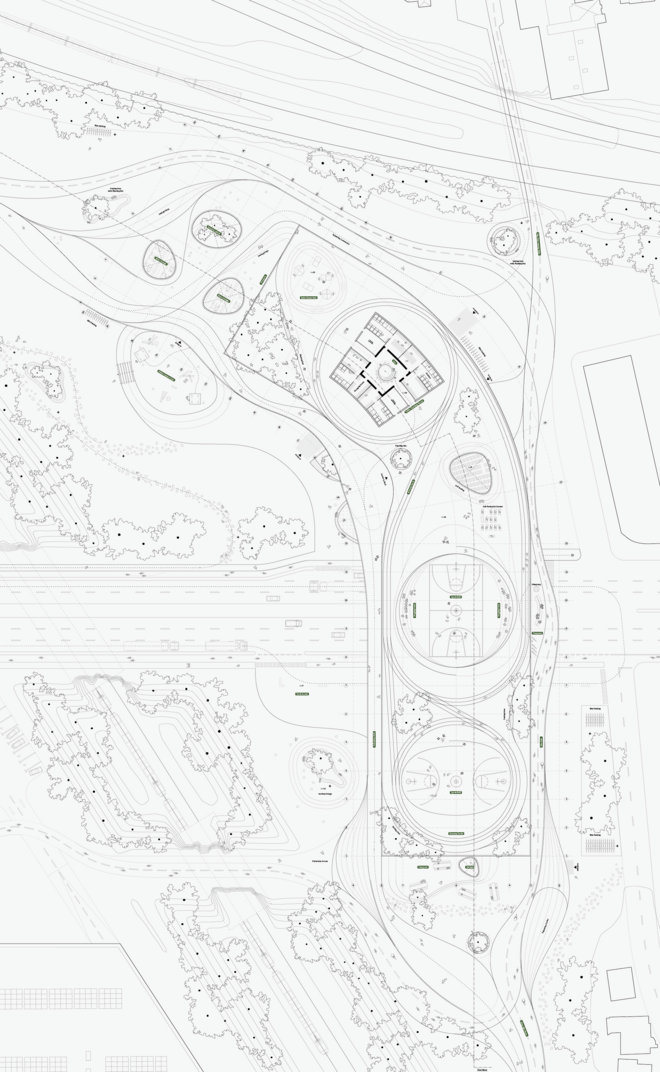
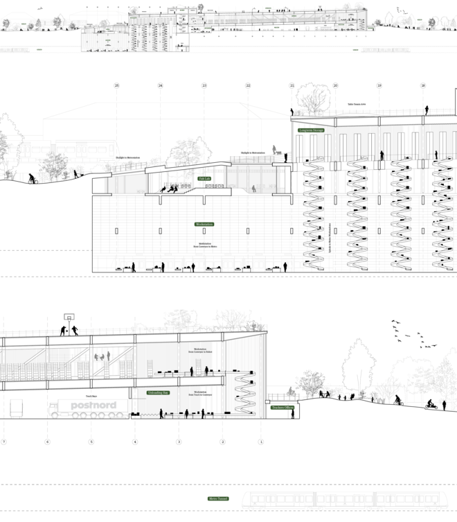
The final form and spatial layout of the building were predominantly shaped in response to the varying flows. With cyclists flowing alongside the building, pedestrians occupying the running track on the roofscape, and vehicles passing below all whilst goods travel from their drop-off station and travel along with the building and down into the metro. Passengers and cargo flows, previously isolated from each other, now enter into a temporal, symbiotic sharing of the facilities.
{c} Landscape
Inevitably the program of logistics produces large planes, however large, the landscape needed to interweave with the existing landscapes of the city. The first landscape we considered was infrastructural, especially with the site surrounded by various mobility infrastructure. Secondly was the introduction of the artificial logistics landscape, and lastly was the public landscape.
In section is where you can experience how the landscape plays a major role in the language and layering of the building. Here the logistics plane is anchored by two green edges, creating a permanent pedestrian bridge over the heavy trafficked 02 ring road and providing a large sports facility on the roofscape directly above the automated logistics landscape.


Det Kongelige Akademi understøtter FN’s verdensmål
Siden 2017 har Det Kongelige Akademi arbejdet med FN’s verdensmål. Det afspejler sig i forskning, undervisning og afgangsprojekter. Dette projekt har forholdt sig til følgende FN-mål