
A
The dangers of rising sea levels and the dynamic environments they create, start to question our practice as architects and designers. Addressing this issue requires the understanding of systematic behaviours outside of our field of expertise. To do this we need tools in our own design environments, which are based on real phenomenons, in order to help us make informed speculations.

Rising temperatures and melting poles, resulting in a non-linear rise of sea-levels. The reduced gravitation pull of the poles makes predictions of the rising sea levels almost impossible.
Cities like Copenhagen, have the tendency of reclaiming land from the sea. With the danger of rising sea levels, we need to start speculating and rethinking how we approach environmental change - do we fight nature with dykes, or do we try and steer it and let it inform our decisions?


I have developed a custom tool in the native environment of rhinoceros and grasshopper3d, in order to be independent of a tool that is designed for engineers, which leaves us in the spot of working with something we don’t understand. We can use computational methods to translate the knowledge of very precise and explicit tools from other disciplines, in our own design evnironments in order to empower us as architects and designers, in order to make informed decisions and build robust speculations, instead of drawing weird islands in the water.


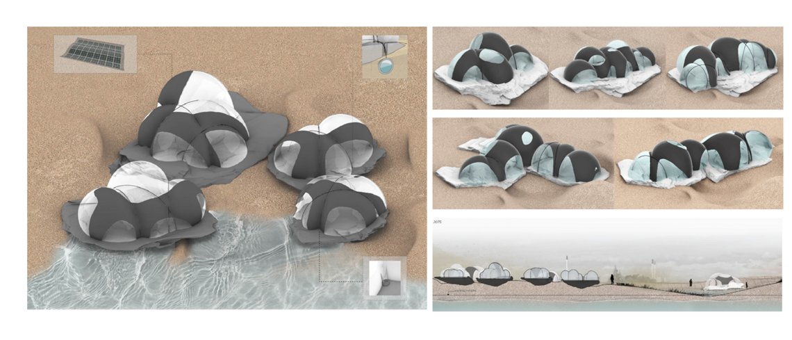
The target design intent aims to create a spatially rich and diverse sandscape. The interventions at this level are abstractions that inform the behaviour of the sand in time. The abstraction will be articulated later. At this scale, I am aiming for design exploration and harvesting the knowledge of the simulation in order to build my intuition as a designer.


When working with dynamic environments, I had to develop a method of understanding and tracking dynamics. The following gallery shows the use of the tool to forecast future events, look into the past and do both at the same time. This gave me an understanding of how different areas change and what is the relationship between interventions and the sandscape.


The same simulation used for the masterplan is used for the scale down plans in order to study the interaction between the sand and the casted foundations. The abstracted regions in the masterplan are now the foundations.


")


