
A

0.0_Project Summary
The topic area of this diploma project focuses on the mining industry in the Pilbara region of Western Australia.
Australia contains some of the world’s largest mineral reserves in particular iron-ore. Contributing greatly to the country’s economy and the global supply of these resources. However, the sites from which these resources are extracted often bring them into direct conflict with areas of both ecological & indigenous significance.
The project is situated within one such site of this ongoing conflict, that of the Paraburdoo Iron-Ore Hub in the Western Pilbara. This mine like the many that surround it, is emblematic of the ongoing competing interests between mining companies, indigenous groups & ecological conservation. However, being one of the oldest mines in the region, the site also presents a unique opportunity to consider what these sites could become following their obsolescence.
This diploma project seeks to explore the spatial potentials for the regeneration and re-inhabitation of these extraction landscapes (informed by indigenous practices) through a strategic masterplan, alongside select landscape zoom-ins and tertiary architectural interventions. Through these scales the project seeks to facilitate the regeneration & re-inhabitation of these extraction landscapes for humans & non-humans, in a post-extraction future.
“...And often it’s not the direct impacts of the mine sites themselves, but it’s the indirect impacts. All the infrastructure that’s needed to service the mines, so all the roads, the pipelines, the town, the ports. It’s that infrastructure that often has the greater impact on bio-diversity than the mines themselves.”
-
Dr Alan Andersen, Ecologist (CSIRO)
1.0_The Societal Theme: Resource Extraction
Australia is a very resource rich and resource diverse country, making the primary industry of mining extremely important to the country’s economy.
Where this extraction physically occurs is often deep within the Australian interior. Far from urban centres. Literally out of sight and out of mind for the majority of the population.


2.0_The Site: The Pilbara Region
However, these space are not empty. On the contrary they are incredibly significant places both ecologically but also culturally. Particularly to the indigenous Aboriginal people of Australia.
This presents a spatial conflict between the notions of sacred land and sacrificial land. This conflict has been going on for over a century. With devastating cultural and environmental impacts.


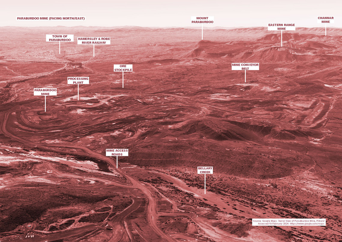
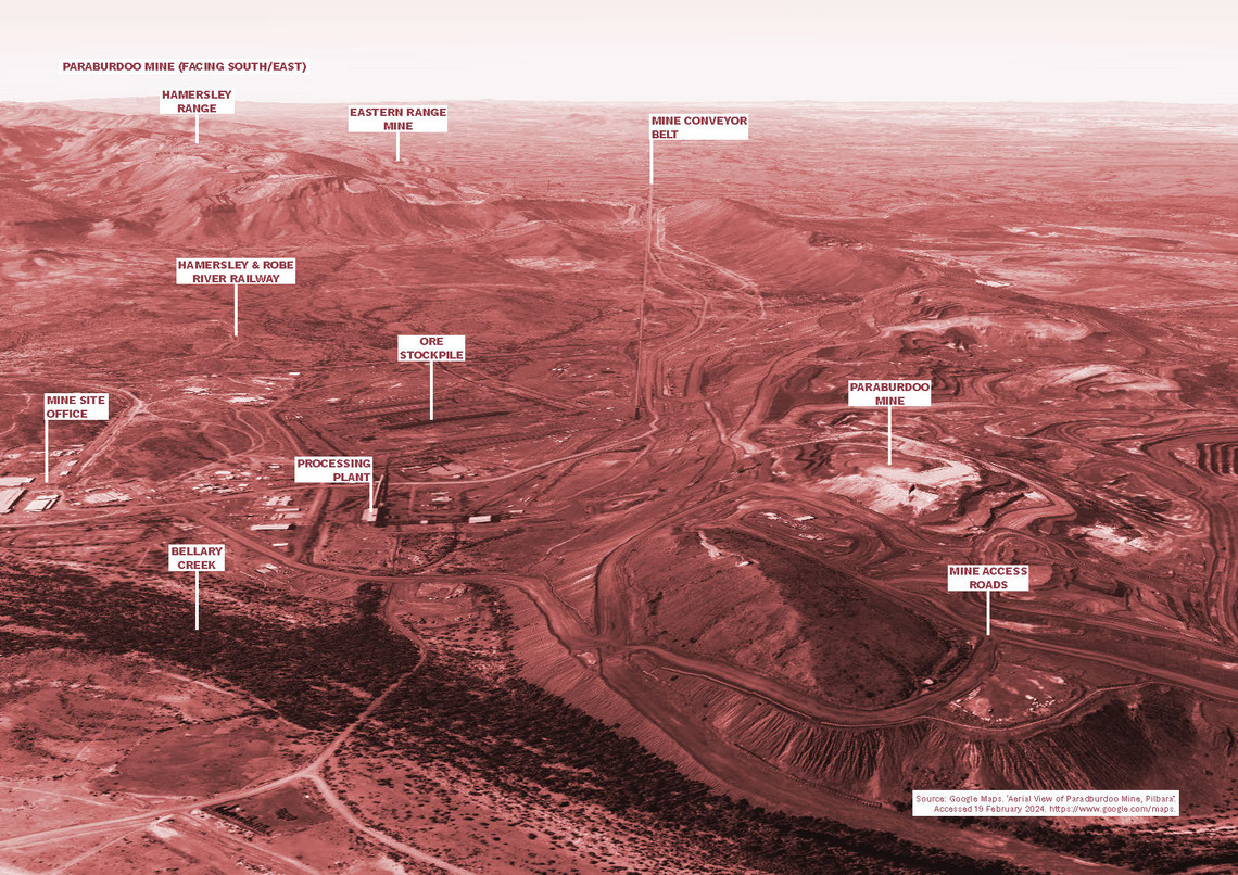
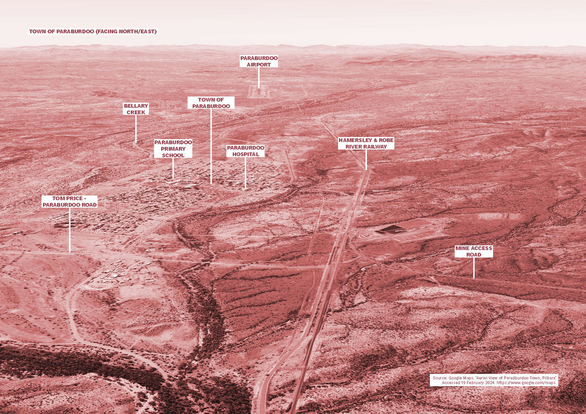
The project is situated within Western Australia the epicentre of Australian mining. Specifically the Pilbara regions which contains the vast majority of the countries iron-ore mines.
Although seemingly a vast landscape, one can see the dominance of mineral extraction on the landscape. As well as the conflict and competing interests that operate within the space.


In terms of site selection. Three sites were short listed due to the on-going indigenous and ecological conflicts. However, the Paraburdoo Iron-Ore Hub was selected due to the mine's age.
Consisting of three mines (Paraburdoo, Eastern Range & Channar), the site sits along the Hamersely Range and within the native title claim of the Yinhwangka people.


3.0_The Project Strategy
The project aims to explore new spatial potentials for environmental restoration, and the human & non-human re-inhabitation of post-extraction landscapes


4.0_The Masterplan Strategy
At the strategic masterplan scale the project operates on a timeline, with each of the key actors playing a concurrent role throughout each stage. The masterplan is unfolded through two transitional stages to achieve the final restoration and re-balancing of the territory. The proposal sees that within each stage a series of spatial moves are implemented by each actor.


4.1_Typologies: Re-Access & Restoration


5.0_The Zoom-Ins: Spatial Resolution for Points of Conflict
The project aims focuses on three specific points of conflict; The Campsite, The Nursery & The Quarry, and offers spatial resolutions to these spaces that promote environmental restoration and human & non-human re-inhabitation.

5.1_The Campsite
Located 2km South/West of the Paraburdoo mine site, along 7 Mile Creek. This traditional Indigenous gathering place was first discovered by geologists in 1975. Currently the site is abandoned and bisected by mine access roads.
The spatial proposal not only imagines a restoration of the Creek's riparian zone, but also the re-establishment of the camp site for the Yinhwangka people. Allowing them the ability to re-access their land and providing them the agency to practice native land management on site.


5.2_The Nursery
Paraburdoo Mine is serviced by an extensive array of processing facilitates and infrastructure. One of the largest structures on the site is the screening plant, used to separate impurities from extracted ore.
In a post-extraction future instead of erasing these structures from the site. Could one imagine re-using these structures to facilitate scientific and environmental conservation.
The project images this building transformed into a nursery, greenhouse and seed bank to assist in the conservation of endangered flora. But also a place of education and larger community gatherings.


5.3_The Quarry
A few 100 metres south of the Eastern Range is the Red Orche Quarry (Indigenous name: Garabagarrangu), which is one of the most culturally significant site for the Yinhwangka people. The site is currently surrounded by access roads and an adjacent mine conveyor belt.
The spatial proposal for the site is to give nature back its agency to restore and regenerate itself. By removing the infrastructure which currently bisects it. Whilst also providing interventions which protect these biotopes, and assists with the recuperation of endangered species.


6.0_The Architectural Interventions
At the tectonic scale this project propose a series of re-use potentials for obsolete mining infrastructure & waste material. Seeing them transformed to support the sustainable inhabitation and restoration of both human and non-humans.


